Summer Certification Limited Time 70% Discount Offer - Ends in 0d 00h 00m 00s - Coupon code = getmirror
Pass the Esri Technical Certification EADP19-001 Questions and answers with ExamsMirror
Exam EADP19-001 Premium Access
View all detail and faqs for the EADP19-001 exam
765 Students Passed
87% Average Score
93% Same Questions
When designing a geometric network where should the feature classes be stored?
An ArcGlS user decides to use labels in a map document because the annotation appears pixelated as the user zooms from the reference scale
What Is a potential effect of this decision?
An ArcGIS user adds two feature classes with different coordinate systems in ArcMap. one at a time. The user starts editing data from the second feature class and is warned about editing the feature class because the coordinate system is different from the data frame.
Where do the edits occur?
An ArcGIS user is tasked with creating a map of the state of Utah displaying all the rivers for a conservation group. The conservation group is only interested in seeing rivers longer than 15 miles, where the longer rivers appear thicker using graduated symbols.
What are two ways the ArcGIS user can eliminate rivers less than 5 miles in length from appearing in the map? (Choose two)
An ArcGIS user is creating a processing environment that will be used repeatedly. To confirm results, the user wants to visualize the output of Intermediate processes during testing. The user is working with large data sets and wants to preserve already-complete steps and focus on one problem at a time.
Which geoprocessing approach should the user consider?
A geosatabase designer has the following requirements regarding the display of city feature names in output map documents:
• The symbology needs to vary depending on city population size
• Names may not conflict with other text or features
• Rendering performance is a higher priority than database maintenance and editing simplicity Which design option should be used to meet these requirements?
A representation layer has been defined using the option to save changes to the geometry of the supporting feature. If the geometry of the feature is modified using the tools from the Representation toolbar, what will be modified?
Refer to the exhibit.
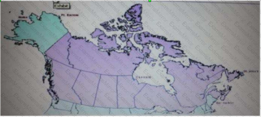
The ArcGIS user is given data for the Arctic, and is asked to perform various types of analysis using the data. The data extends from the North Pole south to 55 degrees North Latitude Data layers may contain points lines, or polygons and include ice surveys from NOAA depth contours; continental margins, locations of known and suspected oil reserves, endangered species habitat and territorial boundaries for nations having Arctic coastline.
An ArcGIS user is asked to calculate the distance a cruise ship will travel through open water, departing from Nome, Alaska, with stops at Point Barrow Alaska Churchill Manitoba St John's Newfoundland and ending in Bar Harbor Maine. On the basis of these calculations the cruise ship line will determine fuel requirements and travel time.
Which map projection yields the most accurate results for this distance calculation?
While attempting to geocode schools within a 20-mile of a museum, an ArcGIS user realizes that the table they are trying to geocode only contains the names of the schools. The table tails to include the school addresses.
Which type of table should the user link to their address locator in order to efficiently display the locations of the schools?
Four emergency response facilities need to be placed so that the greatest number of people in a community can be reached within five minutes.
Which analysis method is used to make this determination?
TOP CODES
Top selling exam codes in the certification world, popular, in demand and updated to help you pass on the first try.