Weekend Special Limited Time 70% Discount Offer - Ends in 0d 00h 00m 00s - Coupon code = simple70

Pass the Esri EADA EADA10 Questions and answers with ExamsMirror

Practice at least 50% of the questions to maximize your chances of passing.
Exam EADA10 Premium Access

View all detail and faqs for the EADA10 exam


336 Students Passed

86% Average Score

92% Same Questions
Viewing page 1 out of 3 pages
Viewing questions 1-10 out of questions
Questions # 1:

An ArcGIS user is analyzing a map containing several high quality data layers. The layers are defined in several different coordinate systems in the same data frame. However, due to the high quality of the data, all features line up with each other almost exactly.

When the user adds a new dataset all features appear to shift to the north by a nearly identical distance. The new dataset is assigned to a different coordinate system than any of the layers that line up correctly.

What are two possible reasons for the features shifting? (Choose two)

Options:

A.

ArcMap's on-the-fly projection is introducing random error in the new dataset

B.

The new dataset is assigned to the wrong projected coordinate system

C.

The wrong geographic transformation is used to protect the new dataset

D.

The new datasets geometry is more accurate than the other layers in the map

E.

The map projection required to project the new dataset is outdated

Questions # 2:

The ArcGIS user works with a map document that contains a very detailed image that takes several seconds to draw when panning.

Which action can the ArcGIS user take that will improve the performance when panning in ArcMap?

Options:

A.

put the image layer in a group laver

B.

set the reference scale on the image layer

C.

put the image laver in a basemap layer

D.

make the image layer selectable

Questions # 3:

An organization manages multiple GIS projects and restricts data access to specific users. Which type of geodatabase should the organization use?

Options:

A.

distributed geodatabase

B.

versioned geodatabase

C.

replica geodatabase

D.

modular geodatabase

Questions # 4:

An ArcGIS user is exporting a feature class to an existing feature data set using the Export Data option from the layer context menu in ArcMap. The feature class coordinate system differs from the feature data set coordinate System.

What will be the coordinate system of the exported output?

Options:

A.

the same as the source feature class

B.

the same as the destination feature dataset

C.

the same as the source input layer

D.

the same as the source data frame

E.

the same as the destination geodatabase

Questions # 5:

An ArcGIS user is creating a road, which will need to be snapped to the border of a land parcel. Which snapping option must be turned on?

Options:

A.

Point snapping

B.

End snapping

C.

Vertex snapping

D.

Edge snapping

Questions # 6:

Which two actions taken by an ArcGIS user result in conflicts being detected during a reconcile operation? (Choose two)

Options:

A.

Changing the same feature in two separate versions of the geodatabase

B.

Changing the same feature in the same version of the geodatabase in different edit sessions

C.

deleting a feature in a child version of the geodatabase, but not in the parent version

D.

deleting a feature in one edit session and altering it in another inside the same version of the geodatabase

E.

changing a feature in a child version of the geodatabase and deleting it in the parent version

Questions # 7:

An ArcGIS user performed a spatial transformation to adjust a less accurate Dataset A to match with a more accurate Dataset B. The Spatial Transformation tool reported a low root mean square error (RMS).

What does this indicate?

Options:

A.

The transformation between the control points is consistent

B.

Too many control points were selected

C.

The accuracy of Dataset A is high

D.

The accuracy of the output transformed dataset is high

Questions # 8:

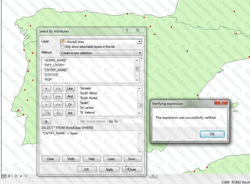
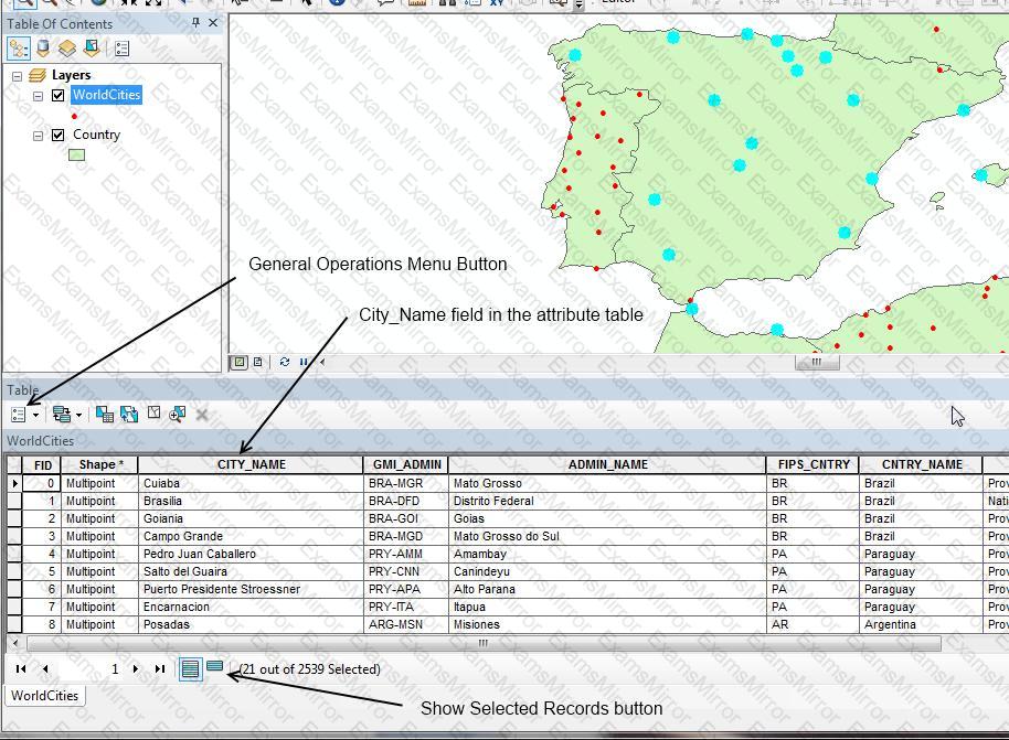
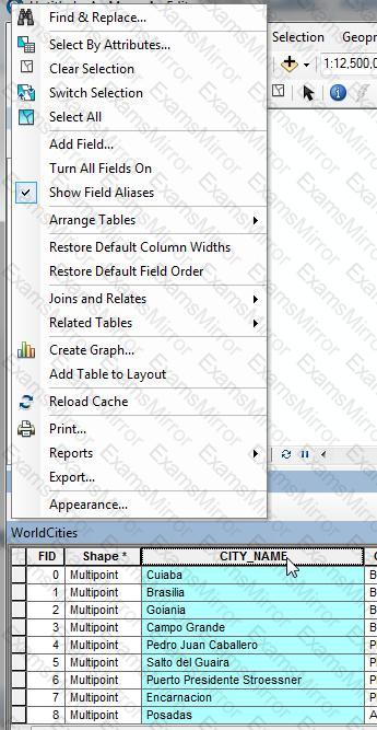
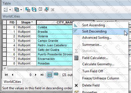
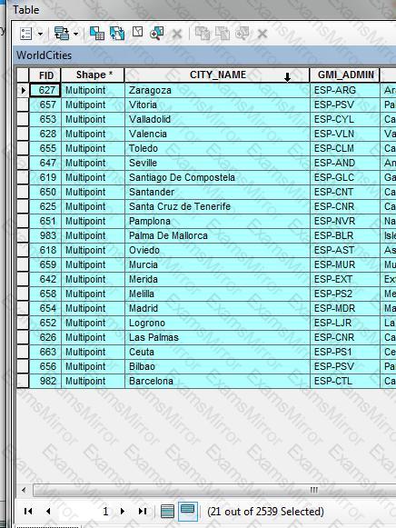
An ArcGIS user wants to display only values for the selected features in an attribute table in reverse alphabetical order (z to A) using the values CityName field.

Which method will give the desired results?

Options:

A.

Right-click the CityName field, choose Sort Descending, click Show Selected Records

B.

Right-click the CityName field, choose Sort Descending, click Summarize

C.

Highlight the CityName field, from General Tabular Operations menu, choose Sort Descending: click switch Selection

D.

Highlight the CutyName field, from General Tabular Operations menu, choose Sort Descending: choose Show Selection

Questions # 9:

An ArcGIS user needs to provide a person outside the user's organization a layer file along with its data. How can this be accomplished in ArcGIS Desktop?

Options:

A.

use the Export as XML Workspace Document tool in ArcCatalog

B.

use the Save as Layer tool in ArcMap

C.

use the Export as Layer tool in ArcCatalog

D.

use the Create a Layer Package tool in ArcMap

Questions # 10:

An ArcGIS user is displaying a parcel feature class under a building feature class. The user wants to ensure that the exact outline of all features is visible.

What must the ArcGIS user do to allow both feature classes to be viewed at the same time?

Options:

A.

spatially join features

B.

set transparency on buildings

C.

join buildings to parcels

D.

relate buildings to parcels

E.

change display order of features

Viewing page 1 out of 3 pages
Viewing questions 1-10 out of questions
TOP CODES

TOP CODES

Top selling exam codes in the certification world, popular, in demand and updated to help you pass on the first try.